Quantcast


Biking paths are numerous in Hartford Connecticut

Air Line Rail Trail -- South

Trail Length: 22.4 miles

Air Line Rail Trail follows the Air Line Railroad track, laid down in 1873. The south section of the trail stretches from East Hampton to Willimantic, with a link at its midpoint to a spur south to Colchester. (The northern section, from Windham to Putnam, is too rough for bicycles.) Round-trip bike riders should start in East Hampton. Over the next 3 miles, you'll cross the Rapallo and Lyman Viaducts. The onward trail soars over streams and the broad Blackledge River before crossing a causeway through Raymond Brook Marsh.
An eighth of a mile from a trailhead and large parking area on State Route 85, the 3-mile Colchester Spur Rail-Trail joins the main line. You'll cross Route 85 and eventually emerge at an undeveloped trailhead anchored by the old Colchester Railroad Station.
Farmington River Trail

Farmington River Trail offers an 8.5-mile excursion along the Farmington River. The southern trail head at Tunxis Mead Park in Farmington also serves as a trail head for the Farmington Canal Heritage Trail. Follow signs to the river trail. Two miles in, the trail follows a quarter-mile road. Cross Route 177 at the crosswalk and head straight on Railroad Avenue.
At the road's end, continue straight on the dirt path and cross River Road. The trail parallels the river and Route 4. The trail follows an old road and passes and old dam. At 7.5 miles, a ramp climbs to a restored train bridge. Good for biking , skating, fishing, walking, cross country skiing. - Trail Map
Vernon Rails-to-Trails

Manchester/Vernon Border to Hop River State Park Trail Manchester, CT Phone:

Trail Length: 4 miles

This pretty trail network overlooks ravines and streams. From the trail head on Church Street, the Vernon Rails-to-Trails Park offers three trail segments: the Hop River State Park Trail leads to the Manchester/Vernon town line; the Vernon section of the trail leads through thick woods to the Bolton town line; and the Rockville Spur reaches a bridge crossing the Tankerhoosen River.
Parking and Trail Access: The Vernon Rails-to-Trails Park is on Church Street between Phoenix and Washington streets.
Trail Activities: Biking walking, cross country skiing. Trail Map
Bike Trail - Stratton Brook State Park - Simsbury, CT
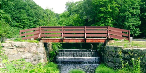
Stratton Brook State Park Trail

Stratton Brook State Park Simsbury, CT, 06070 Phone:

Trail Length: 2 miles

This 2-mile trail has a covered bridge at its midpoint. From the covered bridge, the shaded rail trail shoots northeast and southwest along an old railroad bed. After bridging Stratton Brook and rounding a bend, the trail leaves the park, ending at the Bushy Hill Road and State Route 309. You can get onto the canal trail by turning right on State Route 309 and following the shoulder a half mile. For a slightly longer ride or walk, turn southwest from the covered bridge and cross Stratton Brook Road. From there, the old railroad grade is a paved road for 1.7 miles, where it enters Massacoe State Forest.
Trail Surfaces:Asphalt, crushed stone, cinder
Trail Activities: Bike, wheelchair accessible, mountain biking, walking, cross country skiing
Charter Oak Greenway

Trail Length: 9.8 miles

The Charter Oak Greenway is a paved, multi-use trail connecting parks and neighborhoods in East Hartford. The trail runs for 9.8 miles from Forbes Street in East Hartford to Bolton, including a section using local roads. The trail provides seasonal access to restrooms, picnic areas, tennis courts, and a playground at Charter Oak Park. Bike lockers are at Route 83 and Charter Oak Street and at the Spencer Street commuter lot. Some hills are quite steep.
Parking and Trail Access: From I-384 eastbound, take exit 3 (Route 83). Turn right onto Route 83 North. Turn right at light onto Charter Oak Street. Turn right at light into Charter Oak Field. From I-384 westbound, take exit 3. Turn right at end of ramp onto Charter Oak Street. As above.
Windsor Locks Canal State Park Trail

Canal Road in Suffield to Route 140 Mill Complex in Windsor Locks Suffield to Windsor Locks, CT Phone: 860-242-1158

Trail Length: 4.5 miles

The 4.5 mile Windsor Locks State Park Canal Trail follows the historic towpath of this 170- year-old historic waterway. The canal’s many vantage points offer the trail user scenic vistas of both the Connecticut River and the old canal.
Parking & Trail Access: To start at the Canal Road parking lot, take exit 47W off of I-91 and follow Route 190 West for 1.3 miles. Turn left onto Route 159 South and take the first left onto Canal Road and follow to the parking lot.
To start at the Route 140 Mill Complex parking lot, take exit 45 off of I-91 and go west on Route 140. Just after you cross over the Connecticut River there will be a Mill Complex on your right. Take the narrow road down along the canal to a parking lot. Seasonal Restrictions: The towpath is closed to all uses from mid-November until early April of each year. This is to protect the nesting habitat for endangered birds of prey.
Trail Surfaces: Asphalt
Trail Activities: Bike, fishing, walking